


Articles about maps
History of cartography
All about topographic maps
Topographic maps and traveling
Two centuries of Russian Cartography
Navigation software and offline maps
All about topographic maps
Built-up areas representation on topographic map
Content rules of topographic maps
Digital topographic map and its requirements
Growth representation on topographic maps
Hydrography representation on topographic map
Mountain formaion
Object representation on topographic map
Principles of digital topographic map classification
Programs for working with raster maps
Road representation on topographic map
Soil representation on topographic map
The notion of a map
The process of digital topographic maps creation
Hydrography representation on topographic map
Seaside. Lakeside.
Strip of land, bordering with seaside, together with sea lane, bordering with land, forms seashore that contains characteristics of seaside relief, gulf division, bay, nature of underwater and above water barriers (rocks, reefs, sandbank). Seashore can be mountainous, high or low. Mountainous and high shores usually have a deep-watered seaside with a great number of barriers. Low seaside usually looks like a plain with little shore vault. Seaside of such shores is usually shallow with sandbanks. Shapes of seashores according to their peculiar characteristics can be grouped into the following main types (picture 1): fiord, skerry, firth, lagoon.
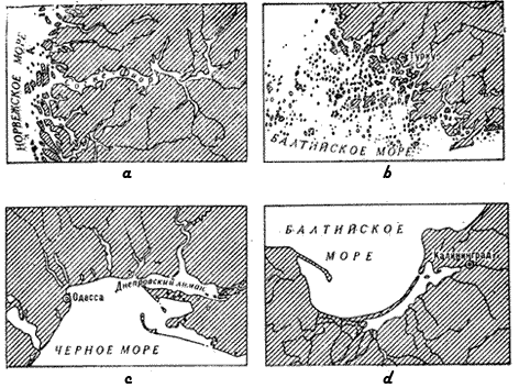
Picture 1. Main shapes of seashores
A - fiord, b - skerry, c - firth, d - lagoon
A big impact on conducting operation near seaside have not only the character of seaside and seashore, coast line outline, coast division, presence of bays, gulfs and channels, but also the nature of soil, growth, manner and height of flows. For landing operation is chosen the area of seashore, which provides necessary dispersal of landed subdivisions and fire connection between them, has necessary depth in the seaside part of the sea that makes possible for ships to come to the coast and have wide strip of land enough for fire and defense organization and bridge-head widening. In this regard the most convenient are low coast that have wide and flat strips of seaside. Big influences on conducting operations also make ebbs and flows. Quantity of flows (raise of water-level) varies: from 7 cm at Baltic Sea to 13 cm at Sea of Okhotsk. Flows change water-level in rivers that fall into sea. Tidal wave flowing into the creek may spread up-stream for hundred of kilometers thus producing water-level raise and backflow. The speed of tidal wave spreading may sometimes be up to 20 km per hour, and the height up to 10 meters.
Coastline mapping of seas and lakes
Coastline of seas and lakes while mapping are subdivided into permanent and definite, variable and indefinite. Sea coastline corresponds with the point of water line when there is the highest level of flow and there is no periods of flood and ebb - line of surf. Lake coastline corresponds with the point of water line when it is mean water (the lowest seasonal water-level standing).
Flood and ebbs lines are depicted on the topographic map in accordance with the type of soil (sandy, stony, gravel, uliginous and rocky). Passability of flood and ebbs lines are given on topographic maps of thinly populated regions. For example: "when ebb track-type vehicle driving is possible". When mapping an average size of flow is depicted with the accuracy to within 0,1 meter, starting from the size of flow more than 1 meter.
Coast sandbanks and dangerous coasts are reflected on topographic maps to show unapproachable for ships seaside.
Lake mapping
On topographic maps with scale 1:25000 - 1:100000 lakes are depicted on condition that its area is more than 1 mm2 and more in the scale of map. Fresh lakes are always depicted in droughty and waterless regions. Mineral water, which has industrial and medicinal value, is as a rule depicted on topographic maps as well as lakes that appeared to be river heads.
Boundaries and squares of floods of big rivers and lakes are depicted on topographic maps when inundated in rain periods and the period of flooding are signed. For example: "Flood period from May till June). All Islands in seas, lakes are as a rule depicted. But when there are a great number of them only the largest are shown.
River mapping
River is a water stream flowing in natural watercourse and filling up by superficial and underground flows of its reservoir. River head is situated near water parting, downstream embraces tributaries and ends at mouth. Hollow in which the river flows is called the vale and its lower part where water flows off - watercourse. The part of vale bottom, flooded in high water is called flood-land of the river. Riversides can be high and low, the bottom - solid (sandy, stony) or viscous (clayey, uliginous, peat).
The main part of the river is watercourse. It consists of interchangeable narrow, deep areas that have relatively quiet flow, called reaches and wide shallow areas with relatively fast flow, called rifts. River watercourse forms numerous bends. Parts of watercourse where river slumps at a considerable speed are to be observed are called rapids. They are usually found where the river flows near pass rocky range or in the places of hard-washed rocks, boulders' gathering.
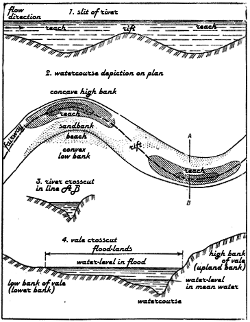
Picture 2. Structure of river vale and watercourse
1. Slit of river
2. Watercourse depiction on plan
3. AB-river crosscut in line AB
4. Vale crosscut
River characteristics depend very much on its water schedule. River schedule is a seasonal fluctuation of water-level with width, depth and flow velocity changes and facts of dryout, freezing and brake. According to the water schedule distinguish high water (annually repeated in one and the same season of a year relatively long water-level increase), flood (relatively short and noncyclic river water-level increase appeared due to snow and ice melting, heavy rains), mean water (continual seasonal low water-level standing in river).
River characteristics
Rivers are divided into mountainous and flat. Mountainous rivers flow in deep vales with narrow bottom, fall obtain several meters per one kilometer, current is rough (up 7 meters per second), bottom is solid (stony), there are a lot of chutes, rapids and waterfalls, bank is steep. Flat rivers flow in wide vales, flow obtain only several centimeters per one kilometer, current is calm (0,1 - 1,5 per second), watercourses are meandering, bottom is solid (sandy), or oozy, banks are sloping.
River network is characterized by density, i.e. relation between total length of all rivers and total square of its basin. It can be sparse (less than 0,2 kilometers per square kilometer), medium (0,2-0,4 kilometers per square kilometer) and dense (0,4 - 0,7 kilometers per square kilometer). Narrow and deep vales of mountainous rivers, especially in its upper reaches, may have difficulties for troops to move. Downstream river its vale little by little becomes wider and its vault flatter.
Flat rivers have skin-deep vales with sloping vaults. Flood-lands of such rivers attain width of 20 kilometers and in dry season of a year it's possible to transport military and other equipment. In autumn and spring and also after heavy rains flat rivers flat-lands are full of water and become impassable for troops.
Presence of convenient water accesses and possibility to equip descents very much depends on river vale vault steepness, its irregularity by ravines and scours.
According to the width rivers are subdivided into narrow (till 60 meters), medium (from 60 till 150 meters), wide or large (more than 150 meters); according to the length - small (till 100 kilometers), medium (from 100 till 150 kilometers) and large (more 500 kilometers). The depth of the river fixes the possibility to ford it or to use various transport means. To organize accessible passage through the river for troops, first of all one should determine places with rifts that allow passing the river along beeline and the shallowest place. Sighs, which help to find ford location, are river widening in its straight area, road and paths that lead to the river, ripples on the water surface (rifts).
One of the most important river characteristic is speed of water flow that has a great impact on place and organization of ford ant choice of special equipment. It influences on duration of ferries run, on possibility of tanks passage under the water, fords' passability. The character of soil also has a big influence on fords' passage, possibility of bridge building, tanks' and other technique's passage under the water. Soft ground quickly damages under wheels and caterpillars pressure. Tanks' passage along river bottom is possible only in case that the soil is firm (sandy, gravel or stony). Oozy bottom weakens to a great extent wheels and caterpillars adherence with soil. Big stones at the bottom make difficulties for wheeled and caterpillar car movement.
Many rivers in lived-in areas are dammed up and have various waterside structures. Using which one can quickly change water-level in the rivers, built up large areas of artificial water flooding and swallowing of one and the same areas on purpose of interdiction of enemy actions. On conducting military operations a great impact also have canals and canalized sections. Its force crossing is much more difficult because of steep well-equipped banks. A big influence on troop's movement has not only wide rivers, but numerous narrow rivers and streams with steep banks and waterlogged flood-lands and also large network of irrigative and drainage channels and drains.
River and streams representation
Rivers and streams while mapping are subdivided into permanent and intermittent. Underground and disappeared parts of a river (when watercourse is not distinctly expressed) are reflected by means of special conventional signs. On map the following features are represented in detail: character and drainage density, exact watercourse location, main rivers and also show connection between river network and other elements of locality. All rivers are represented in one or two lines depending on its width. River bank line, represented with real width in map scale, corresponds with the point of water bank line during mean water.
Canals representation
Canals (dynamic, under construction or underground) and drains are depicted on map in one or two lines depending on its width. Irrigative and drainage canals are represented on map as a rule with holding its rigidity, accuracy of steering angle and with mapping its mainstreams and density.
Waterfalls and rapids representation
River waterfalls and rapids are as a rule always showed on maps. Its depiction consists of writing words "waterfall" or "rapid", and numerical sign of water high fall in meters. While depicting small rivers on maps of mountainous regions only the most significant rapids are shown, that which have its own names. While depicting rivers and canal with width more than 5 meters on maps with scale 1:25000 - 1:200000 are signed: width, depth, character of bottom soil (on maps with scale 1:500000 only width and depth). Drains with depth from 3 to 5 meters are signed the same as rivers, but without character of bottom soil. Irrigative and drainage canals with width more than 3 meters are depicted with signs of width, depth, dry canals - with signs of only width. In case of considerable depth of dry drains (more than 2 meters) along its depiction depth is signed.
Rivers, canals and drain with constant stream are depicted with arrow along its depiction, which shows current direction. On maps are showed surface current speed of rivers depicted in 2 lines. On maps are showed marks of water edge of rivers, lakes and reservoirs.
Fords represantation
Fords through rivers with width more than 5 meters on maps with scale 1:25000 - 1:100000 are as a rule all depicted. Its depiction is accompanied by the sigh "ford" with characteristic and pointing the deepest place of the river along the passage, ford's length, character of bottom soil speed of surface current. Fords with width less than 5 meters are accompanied only by the sigh "ford". On maps with scale 1:200000 ford's characteristic can be found at ford depiction only if the a river has width at least 10 meters.
Wells representation
On maps of arid and waterless regions wells and other springs are always depicted. Near wells' depiction which does not have its own name one can find just sign "well". Main wells with a great quantity of water supply, good water quality, location near road network are signed by means of special conventional signs. Depiction of main, artesian wells and other important springs is mapped together with the characteristic of water-level, depth of a well, qualitative water peculiarities (salty', bitter-salty) and well's or spring's water production. Wells where there is no water (dry or covered up over the earth) if depicted are also accompanied by characteristics.
On maps of regions with good water supply are showed only those wells and springs that are situated outside of built-up areas and have guiding line (location on hills, distant from other springs).
On maps of arid and waterless regions constructions for gathering rain and ground water (rainy pits, reservoirs, drainage basins) are represented. Depiction of big constructions in the map scale are signed with Roman numerals, which show months where there is water in reservoirs, for example: III - VI (there is water from March to July in reservoir).