


News about maps
Digital cartography and GPS navigation
Mapstor news
This Day in History
Travelling with mapstor.com
Digital cartography and GPS navigation
115 years of flight
Next-generation of GPS satellites are headed to space
DJI Phantom 4 RTK - cartography of a new generation
Earthquake prediction systems
OneSoil map
Form of the Earth
Before we begin to compile or study the maps of the planet on which we live and which is therefore of greatest interest to us, it is necessary to study its shape and dimensions. So we learn to determine the position of points on its surface and define some of the geometric features of the Earth, which were of interest to scientists since antiquity. Already Claudius Ptolemy in Geography wrote: "The first thing to study [in order to create a world map] is the shape, size and position of the Earth relative to its surroundings [sky] so that we can talk about its known part, however great it may be [...].
This is the purpose of geodesy. The word "geodesy" comes from the Greek "geo" ("earth") and "daio" ("divide"), it means "division of the Earth". Geodesy is a science that studies the shape and dimensions of a planet, its gravitational field and the trajectory of motion. In geodesy, you can not do without geometry - the very similarity of these words suggests an important connection between them: "geometry" comes from the Greek "geo" ("earth") and "metria" ("measure"), that is, means "measuring the Earth."
Today the question of what form the Earth has, may seem even somewhat offensive: as we all know, our planet is round like a ball, and flattened at the poles (that is, in mathematical terms, its shape is closer to an ellipsoid). Also at school we were taught: people were convinced that the earth was flat until Christopher Columbus proved to his contemporaries that it has the shape of a ball.
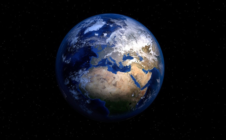
Satellite images of the Earth prove that our planet is round, not flat.
In our minds, the idea that the Earth is round that we do not think to argue with it. But what are the direct proofs that the Earth is actually round? One of them can serve as numerous satellite images, which show that our planet has the shape of a ball. But even if we reject the unlikely conspiracy theory, according to which these images - fake, we still can verify that the Earth is round.
Looking at the sky, we, like the ancient Greeks, discover the first proof of this: the heavenly bodies - the Sun, the Moon and the planets - have a round shape. The shadow that Earth throws on the moon during a lunar eclipse is also round.
Lunar eclipses provide one more proof, albeit not so obvious: they are observed in all parts of the Earth on the same day, but at different times. If the Earth was flat, lunar eclipses would be observed in all its parts at the same time, because in this case the time in all its parts would be the same. This is due to the fact that time on Earth is determined depending on the position of the sun in the sky. Noon, that is, the period when the Sun is above everything above the horizon, sets in different parts of the Earth at different times, since the Earth is round, but if our planet were flat, noon would everywhere come simultaneously.
In the sky one can see another, very convincing proof: when the traveler moves to the north, the stars and constellations are shifted to the south and gradually disappear behind the horizon. In the north, other stars gradually appear, which the traveler could never see at the starting point of his voyage. So, if we are in the Southern Hemisphere, the Polar Star will not be visible to us. But when we begin to move north and cross the equator, it will appear above the horizon and gradually rise higher and higher. When we reach the North Pole, the North Star will be exactly above our head.
In a flat world this would not happen - in all its corners in the sky, the same constellations would be visible.
If we drop the look and focus it on the horizon, we will also see evidence that the Earth is round (it is best to be on the coast or on a ship in the open sea). We will see that the horizon line curves to the edges - in a flat world it would not be so distorted.
But here is the most convincing and indisputable proof that the Earth is round. Let's say that we stand on the beach and watch the sailboat move from us towards the horizon. If the Earth were flat, the sail would grow smaller and smaller until it became completely indistinguishable. But in reality this does not happen: when the ship sails away, first its sight disappears from sight, then - the deck, sails and, finally, the top of the highest mast with a small flag flying in the wind. The reason for this is the curvature of the globe. We see a similar picture when we look at how a traveler is hiding behind a hill: first his legs disappear, then his body and finally his head.
Moreover, it is thanks to this effect that the horizon looks like a thin line between the sea and the sky - if the Earth was flat, the zone between the sea and the sky would be indistinct, and it would be impossible to distinguish the horizon line.
Digital cartography and GPS navigation 12-04-2018