News about maps
Digital cartography and GPS navigation
Mapstor news
This Day in History
Travelling with mapstor.com
Mapstor news
Track plotting and storage in SAS.Planet
Navigation software and offline maps to use with our maps
Transfer to HTTPS
Preview of maps in full size
Added 1443 large-scale topographic maps
Navigation software and offline maps to use with our maps
Dear customers,
For your convenience we prepared a number of articles about navigation using our maps. In this and subsequent articles we will tell you about free programs to be used on your PC, tablet/smartphone, GPS and provide manuals how to use this programs with our maps. We hope that this information will be of use to you. If you have any question, please contact us at info@mapstor.com.
Navigation software and offline maps
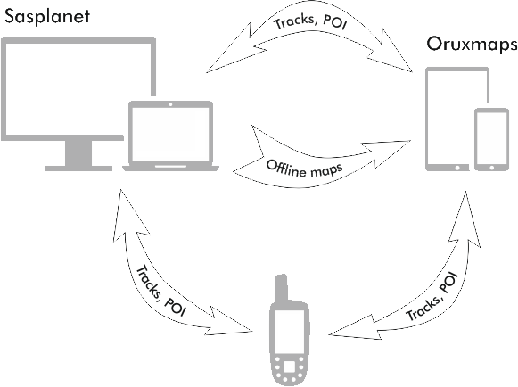
- Sasplanet - navigation for PC
Free navigation software ran on the basis of almost every online map service, as well as on the basis of custom offline maps. It allows you to combine data from different services on a single substrate and quickly switch between data sources. The program enables you to conveniently organize process of making and editing routes together with tracks and POI indexing system. One can work offline, export selected regions in the form of offline maps for other applications.
- OruxMaps - navigation on smartphones and tablets running on Android
https://play.google.com/store/apps/details?id=com.orux.oruxmaps
Free program to navigate using online or offline maps, make and follow routes, measure distance, manage POI, etc.
- iPhone maps - navigation on smartphones and tablets running on iOS
http://www.apple.com/ios/maps/
Utilities:
- GpsBabel - universal converter of track waypoints
It allows you both to convert data and directly exchange information with GPS navigators.
- GlobalMapper - GIS program, maps converter
http://www.bluemarblegeo.com/products/global-mapper.php
Free download of torrent file here.
GIS program that makes it possible to prepare custom offline maps, what is only one function from huge number of others.