


News about maps
Digital cartography and GPS navigation
Mapstor news
This Day in History
Travelling with mapstor.com
This Day in History
4th December, 1674 Marquette founded the first European settlement
19th November, 1875 was born Hiram Bingham
18th November, 1832 was born Nils Adolf Erik Nordenskiöld
14th November, 1963 the island Surtsey was founded
11th November, 1729 was born Louis Antoine comte de Bougainville
4th November, 1493 Guadeloupe Island was discovered
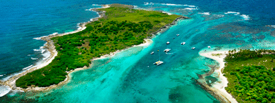 On the 4th of November, 1493 during the 2nd expedition Columbus discovered and mapped the island of Guadeloupe. The locals called this island Karukera, which translates as "Island of beautiful waters." Indeed, the water around has beautiful emerald color.
Columbus renamed the island and named it Santa Maria Guadalupe Extremaduran after a Spanish monastery. Over time, the name was reduced to one word, and now appears on the map as Guadeloupe.
Scientists estimate that Guadeloupe has been inhabited as early as 300 years BC by Arawak Indian people who were engaged in agriculture and fishing. In the VIII century, the Caribs settled the island, which drove the local people and named the island Karukera. Warlike Caribs had a reputation of cannibal and in 1528 they killed and ate the famous explorer Giovanni da Verrazzano.
In 1635 French conquered the island and destroyed most of the Caribs. French colonialists founded a sugar cane plantation, and for the work they brought blacks from Africa. Slavery was abolished in Guadeloupe only in 1848. However, the colonial domination for a long time led to a one-sided development of the economy: there were engaged only in agriculture (coffee, cocoa , sugar cane, bananas).
Topographic map shows that Guadeloupe is located in the West Indies, belongs to the group of the Windward Islands of the Lesser Antilles archipelago between the Atlantic Ocean to the east and the Caribbean Sea to the west.
Modern political map of the world shows that Guadeloupe is a French Overseas Department, a total area of 1,628 sq.km. It consists of two islands - Basse-Terre and Grande-Terre, which are separated by a narrow. The bulk of the population is blacks and mulattos, a total of more than 400,000 people.
This Day in History 04-11-2013