


News about maps
Digital cartography and GPS navigation
Mapstor news
This Day in History
Travelling with mapstor.com
This Day in History
4th December, 1674 Marquette founded the first European settlement
19th November, 1875 was born Hiram Bingham
18th November, 1832 was born Nils Adolf Erik Nordenskiöld
14th November, 1963 the island Surtsey was founded
11th November, 1729 was born Louis Antoine comte de Bougainville
14th March, 1864 was discovered Lake Albert
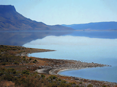 On the 14th of March, 1864 English explorer Samuel White Baker was the first European to visit the lake, which he named in honor of Queen Victoria's husband - Albert. Natives called it Lake Unior Mvutan - Nzige. On the geographic map the lake can be found on the coordinates 1 ° 41 ' n.l. 30 ° 55 ' e.l. in East Africa on the border between the Democratic Republic of Congo and Uganda.
Baker went to the lake on the south side and then proceeded along the east coast to the northern tip and reached the confluence of the Nile, flowing from Lakes Kyoga and Victoria. Aloof researcher also found the output of the Nile from the northern part of Alberta, quietly tapering and rolling in the river valley.
Later traveler recalled: "Far below was a boundless expanse of water like a sea of mercury, from the depths of the lake rose blue mountains to a height of 7,000 feet above its level." Indeed, the newly discovered lake edged ridge to the west, which Baker called the Blue Mountains. On modern maps this name is changed.
In 1866 London Baker's book was published, in which he presented the results of his research work. He managed to correctly identify the position of the lake in the hydrographic system of the Upper Nile. Baker described the lake as "a vast reservoir, which should all flock."
The only thing Baker miscalculated - is the size of Alberta. Researchers estimate that the length of the lake is 480km. If you study a topographic map, you will notice that in fact the length is 145 km . Width has been exaggerated by half. The volume of water in the lake is 132sq. km , area – 5300 km, depth reaches 58 m.
This Day in History 14-03-2014