


News about maps
Digital cartography and GPS navigation
Mapstor news
This Day in History
Travelling with mapstor.com
This Day in History
4th December, 1674 Marquette founded the first European settlement
19th November, 1875 was born Hiram Bingham
18th November, 1832 was born Nils Adolf Erik Nordenskiöld
14th November, 1963 the island Surtsey was founded
11th November, 1729 was born Louis Antoine comte de Bougainville
18th February, 1911 Lake Sarez was formed
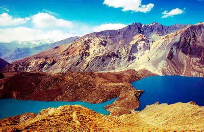 On the 18th of February, 1911 earthquake of 9 points caused landslide that buried the entire village Usoy and blocked Murghab River. As a result was formed Usoy Dam - a natural dam of 567 meters. In the same year depression filled with water and flooded the village Sarez, which later became the name of this place. Initially Sarez Lake was stagnant, but in 1914 appeared springs.
The lake is 55.8 km, depth is 500 m, water volume is 16 sq. km. A topographic map shows that water boundary is about 3263 meters above sea level. While the surrounding mountains rise over Lake Sarez to 2416 m.
During research in 1967 experts found on the right bank of Lake Sarez dangerous section of unconsolidated sediments with volume of 1.25 sq. km. This means that when a new earthquake starts one more landslide can happen. In this case, the landslide will water bank , which spill over the natural dam, dilute it and create a powerful mudslide. Breakthrough of Usoy Dam can provoke a drain of the lake that later can turn out in powerful and long mudslide.
If you open a map, you will notice that Lake Sarez is located in the Pamir (Tajikistan). However, in developing the above scenario, large areas (up to the Amu Darya) will be flooded, and therefore will be destroyed settlements and industrial facilities not only in Tajikistan, but also in other countries (Turkmenistan, Afghanistan and Uzbekistan). Currently potentially dangerous area is home to about 6 million people.
In 2000 The World Bank has triggered an international project called " Lake Sarez: Project to reduce the risk".
This Day in History 18-02-2014