


News about maps
Digital cartography and GPS navigation
Mapstor news
This Day in History
Travelling with mapstor.com
This Day in History
4th December, 1674 Marquette founded the first European settlement
19th November, 1875 was born Hiram Bingham
18th November, 1832 was born Nils Adolf Erik Nordenskiöld
14th November, 1963 the island Surtsey was founded
11th November, 1729 was born Louis Antoine comte de Bougainville
30th August, 1873 the Arctic archipelago of Franz Josef Land was discovered
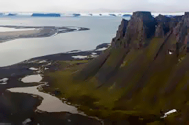 On the 30th of August, 1873 explorers Carl Weyprecht and Julius Payer discovered and studied the uninhabited archipelago. Later it was called the Franz Josef Land, in honor of the Emperor of Austria Empire.
In 1872 Austrian crew under the command of Payer and Weyprecht went on an expedition in a steam ship "Tegetgoff." The main goal was to find the shortest sailing Northeast passage between the European part of Russia and the Far East. But contrary to expectations, the ship was trapped by ice in the north-west of Novaya Zemlya (on the map it is an on archipelago in the Arctic Ocean, located between the Kara and Barents Seas).
On 30th of August expedition approached the coast of an unknown archipelago. During 1873 explorers studied the southern part of the archipelago, and in 1874 crossed it from north to south and made the first map.
In the period from 1895 to 1897English explorer Frederick Jackson carefully studied the southern, south-western and middle part of the Franz Josef Land, and noticed that the map of Payer has some inaccuracies. In particular, an archipelago consists of more islands, and they are smaller than shown on the map.
If you study the topographic map more carefully you can see that the Franz Josef Land - a truly unique place, consisting of 191 islands with a total area of 16,000 square meters. 90% of the surface is covered with eternal ice of the archipelago.
In 2008 during the expedition on a nuclear icebreaker "Yamal" island of Yuri Kuchiev, located in the southeastern part of the archipelago Norbruk, was discovered and mapped.
This Day in History 30-08-2013