


News about maps
Digital cartography and GPS navigation
Mapstor news
This Day in History
Travelling with mapstor.com
This Day in History
4th December, 1674 Marquette founded the first European settlement
19th November, 1875 was born Hiram Bingham
18th November, 1832 was born Nils Adolf Erik Nordenskiöld
14th November, 1963 the island Surtsey was founded
11th November, 1729 was born Louis Antoine comte de Bougainville
31 July, 1498 Columbus discovered Trinidad Island
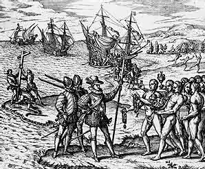 On the 31st of July, 1498 during the third expedition across the Atlantic on six ships, Christopher Columbus discovered the island of Trinidad (Trinity), named in honor of God the Father, God the Son and the Holy Spirit.
During the trip, Spanish sailors ran out of drinking water, and they went ashore to replenish stocks. In front of themselves they saw a flowering island and decided to bypass it searching for local population. The next day the travelers saw a canoe with warriors, which sailed from the south-western part of the island. Following the instructions of the king, the Spaniards decided to express their peaceful attitude and began to dance. However, the islanders regarded it as a war dance, and began to shoot arrows. In response strangers resorted to guns and the islanders disappeared. Meanwhile, Columbus ordered his team to follow from the island to the mainland, which was already in sight. Explorers entered the Gulf of Paria, reached the mouth of the western branch of the delta of Orinoco and the peninsula of Paria. These discoveries laid the foundation for the study of South America.
Christopher Columbus - a Genoese by birth, a great explorer and cartographer, who made the official discovery of America, undertook an expedition across the Atlantic from Europe to the southern hemisphere, down to the coast of South America. Owing to his voyages the map of the Earth was becoming more and more accurate. Its merits include the opening of the Caribbean and Sargasso Sea, the Antilles, the coasts of South and Central America. Columbus' voyage took place in the era of colonization of the land, it contributed to the change of the medieval world and the emergence of colonial empires.
Some historians believe that Columbus was supported by a well-known geographer, Paolo Toscanelli, who believed that the Earth is round. Thus Toscanelli drew a map of the world, backed by the explanation of the possibility to reach India, if one follows the west. When a geographer, received a letter from Columbus, he sent him back a copy of his map, on which China and India were depicted, where in fact is the American continent. The map had an error due to the fact that Toscanelli incorrectly calculated the circumference of the globe, in connection with which India was depicted very close to the coast of Europe. This made Columbus to travel, and reinforced the idea that he was the first to reach India, following the western path.
Christopher Columbus was not the discoverer of America: hundreds of years before him the island and the coast of North America were visited by Normans. But the fact that the discoveries of Columbus had historical significance is undeniable. On a map of South America there is a state that is named after him. If you examine a map, you can also find the Federal District in the U.S., a province in Canada, capital of Sri Lanka, lakes, waterfalls, rivers, mountains, headlands, which are named in honor of Columbus.
This Day in History 31-07-2012