


News about maps
Digital cartography and GPS navigation
Mapstor news
This Day in History
Travelling with mapstor.com
Digital cartography and GPS navigation
115 years of flight
Next-generation of GPS satellites are headed to space
DJI Phantom 4 RTK - cartography of a new generation
Earthquake prediction systems
OneSoil map
First large-scale geological map turns 200 years
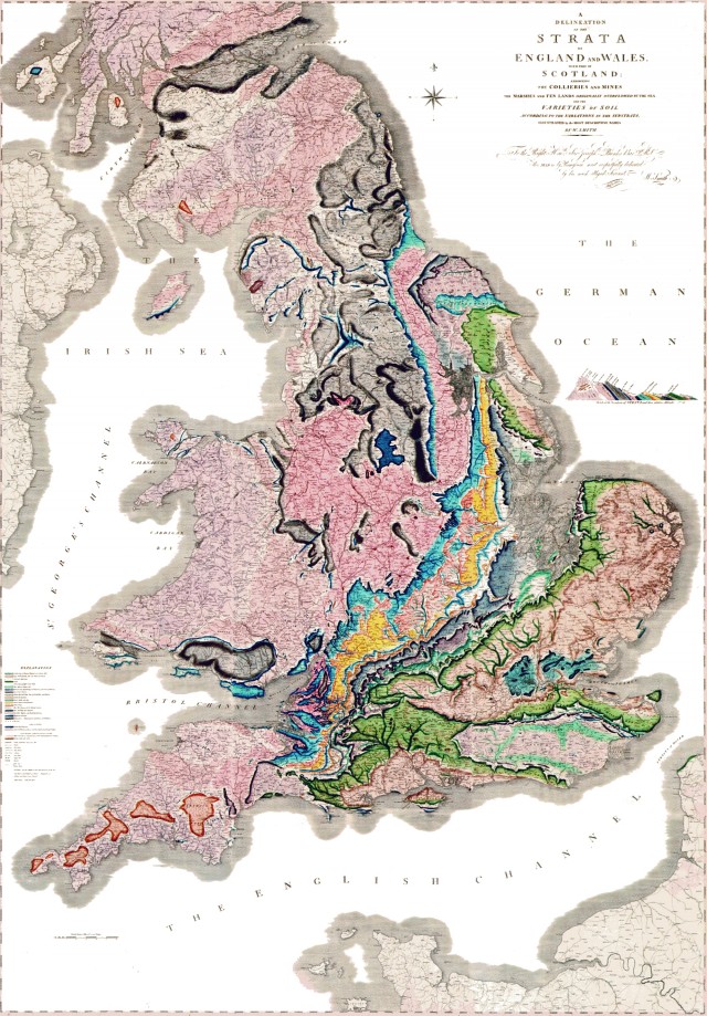 This year marks 200 years since the event that defined modern geology: William Smith, English geologist in 1815 published the first large-scale geological map, which depicted the whole England, Wales and a part of Scotland. His map contains ordered mountain formations with marked fossils they contain.
The oldest geological map extant is considered to be Turin Papyrus Map, created in the 12th century in ancient Egypt, which depicts a 15-kilometer section of Wadi Hammamat indicating villages, hills, gold mines and quarries, as well as the distances between them.
In 1683, Martin Lister suggested the Royal Society to indicate on maps soil and minerals. This is considered the time of birth of the geological survey and geological maps.
William Smith was not a bored rich aristocrat or a geologist by training. He supervised the construction of canals and drainage facilities. And in the process, he drew attention to the fact that the geological formations on the earth's surface are not arranged randomly. They are divided into layers in sequence, and the order is maintained throughout the country. He also realized that fossils can be used as an indicator of the age of the layers. Given its importance to the history of geology, Smith’s story can be found in many books about the history of science, as well as Simon Winchester’s popular The Map That Changed the World.
Digital cartography and GPS navigation 06-02-2015