


News about maps
Digital cartography and GPS navigation
Mapstor news
This Day in History
Travelling with mapstor.com
Digital cartography and GPS navigation
115 years of flight
Next-generation of GPS satellites are headed to space
DJI Phantom 4 RTK - cartography of a new generation
Earthquake prediction systems
OneSoil map
Google Earth Now 'Live From Mars'
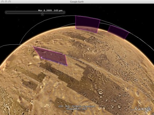
Google Earth announced a big update today of its Mars features, including a chance to see a continuous stream of new, high resolution satellite imagery just hours after NASA receives them. Called "Live from Mars," this section features imagery from NASA's THEMIS camera on board the Mars Odyssey spacecraft, and the HiRISE Camera from the Mars Reconnaissance Orbiter. You can become one of the very first people to lay eyes on images taken just days or even hours ago. You can also see live satellite orbital tracks, or check out where these cameras plan to image next.
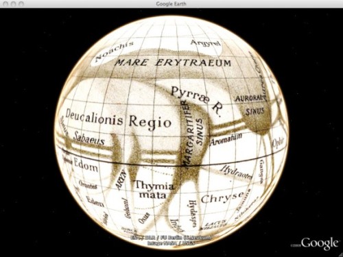
But wait! There's more! Users can also travel back in time to see the Red Planet through the eyes of the pioneers of Mars science in the 'Historical Maps' layer by exploring antique maps by astronomers Giovanni Schiaparelli, Percival Lowell, and others. But also, if you don't know exactly where to start with your Mars exploration, there are guided tours of Mars narrated by Ira Flatow of Public Radio's Science Friday and Bill Nye the Science Guy, allowing you to enjoy the PB&J (passion, beauty and joy) of the Red Planet through their eyes.
So how do you enjoy these new features? Open Google Earth, and after selecting 'Mars' from the toolbar in Google Earth, users fly to a 3D view of the Red Planet, complete with informational layers, imagery, and terrain. The tools for navigation and exploration on Mars are identical to those on Earth - zoom in and out, change the camera view, or spin the entire planet with a click of the mouse.
Google's Communication and Public Affairs officer Aaron Stein noted the "Live From Mars" imagery is the most current available from the THEMIS camera. " Our live imagery is the most current available imagery from THEMIS," he said. "It's not unusual for NASA to save up and download one or two days of images at a time, so downloads do not always occur within hours of image acquisition. Despite this, Live from Mars is orders of magnitude more "live" than the typical NASA public data release process, which for Mars imagery typically takes many months."
Digital cartography and GPS navigation 13-03-2009