


News about maps
Digital cartography and GPS navigation
Mapstor news
This Day in History
Travelling with mapstor.com
Digital cartography and GPS navigation
115 years of flight
Next-generation of GPS satellites are headed to space
DJI Phantom 4 RTK - cartography of a new generation
Earthquake prediction systems
OneSoil map
Volunteers helped to rescue Nepalis, updating maps
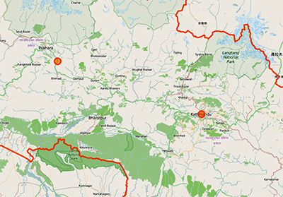 To help the victims of the terrible earthquake in Nepal a lot of rescuers arrived from all over the world. But there were people who were able to help the rescue operation, even from their offices and homes. Working at the computer, they facilitate the work of those who fought with the natural cataclysm on site.
This refers to an open project OpenStreetMap, where volunteers manually edit maps based on satellite imagery and GPS data. But if in the so-called "developed countries" almost all details of big cities are reflected in the vector maps, in such country as Nepal, and especially for its sparsely populated areas, this information has been extremely scarce.
For 48 hours, more than 4,000 people have mapped more than 21,000 kilometers of roads and 110,681 buildings. As a result, data on roads increased in four time, and the number of charted buildings increased by 30%. Trails, recreation centers, ferries and other points critical to emergency services were as well depicted on maps.
Using survey data received within a few hours after the incident, the moderators of the project were able to mobilize volunteers primarily to map the ways in which people can escape from the affected areas.
This kind of help was provided by volunteers, who updated maps during the earthquake in Haiti in 2010, and outbreaks of Ebola. Simple interface and verify of the operations by more experienced participants makes it possible to quickly start using project, even for those who was not previously engaged in mapping.
Digital cartography and GPS navigation 13-05-2015