


News about maps
Digital cartography and GPS navigation
Mapstor news
This Day in History
Travelling with mapstor.com
Digital cartography and GPS navigation
115 years of flight
Next-generation of GPS satellites are headed to space
DJI Phantom 4 RTK - cartography of a new generation
Earthquake prediction systems
OneSoil map
Google Earth Vulcan Project
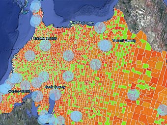 Google Earth can now give Americans a true view of their carbon emissions, at least those emissions that they made in 2002. This data is from Purdue University researchers who fused together Landsat 5 satellite imagery, U.S. Environmental Protection Agency (EPA) carbon dioxide emissions data, U.S. Department of Energy (DOE) and U.S. Census Bureau population data. The project was partly funded by NASA, in concert with the U.S. DOE.
The released fusion of multiple data sources has created a truly phenomenal map of greenhouse gas (GHG) emissions and a plethora of data to go with it. Google’s interactive maps provide GHG emissions from 48 different types of fossil fuel use, including GHGs from power plants, cars, industry, commercial locales, aircraft, homes and from natural sources. The data is available as a timed series showing hourly variations.
Project "Vulcan" (Roman God of Fire) data has been available since April 2007, but it has only just been made available in an easy to understand manner for anyone who has access to the internet and Google Earth. Kevin Gurney, an assistant professor of Earth and Atmospheric Sciences at Purdue University and leader of the Vulcan Project said, "From a societal perspective, Vulcan provides a description of where and when society influences climate change through fossil-fuel carbon dioxide emissions.” He goes on to explain that “Users can see their county or state in relation to others, and see what aspects of economic activity are driving fossil-fuel emissions. Vulcan could help demystify climate change and empower people in the same way as seeing the miles-per-gallon number on the dashboard of a hybrid car."
This database now allows researchers, decision-makers and policy-setters, the opportunity to measure how their decisions can influence global warming via the release of GHGs into the atmosphere. It allows climatologists to understand the interaction between GHGs and weather patterns. It gives the government the means to apportion a GHG taxation system in an accurate and verifiable manner. It gives the public the ability to understand how their actions, and those of business, industry and government, will affect the climate.
The Vulcan Project information is a great portal for NASA's Aqua spacecraft and next week’s launch of the Orbiting Carbon Observatory. The Vulcan guys are now working on giving us the same data for Canada and Mexico. Let’s hope they can eventually do the same for the entire planet, and update the information to show us all what we are emitting last week, so we can reduce it next week...in fact, they have already started work on this and it is called the HESTIA project.
Digital cartography and GPS navigation 22-02-2009