


News about maps
Digital cartography and GPS navigation
Mapstor news
This Day in History
Travelling with mapstor.com
Digital cartography and GPS navigation
115 years of flight
Next-generation of GPS satellites are headed to space
DJI Phantom 4 RTK - cartography of a new generation
Earthquake prediction systems
OneSoil map
Routes on OpenStreetMap.org
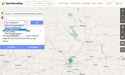
Now on the website OpenStreetMap.org you can make routes from point A to point B (the code on Github).
The interface is written on Javascript, and the routes are imported from third-party services. At the moment these are OSRM, GraphHopper and MapQuest Open. It's pretty original and clever solution: in which case, the provider can be quickly changed. Providers use database of OSM, so it is fair to burden their requests for route and take the result.
OpenStreetMap is able to plot a route to travel by car, bicycle or on foot. Each of the options has two external providers.
In its turn, OpenStreetMap hopes that the built-in navigator will increase user activity on editing maps and descriptions of unmarked objects. After all, when you move from area one sees a different perspective, in more detail. That is, you will notice such details, which are not visible on map without routes. For example, the lack of a left turn on the map, even though this change is possible on a real road. Or part of the road "for buses only."
In general, all indifferent people are invited to edit and further Routes on OpenStreetMap.org . Map data should belong to the people and not be owned and controlled by corporations!
Digital cartography and GPS navigation 28-05-2015