


News about maps
Digital cartography and GPS navigation
Mapstor news
This Day in History
Travelling with mapstor.com
Digital cartography and GPS navigation
115 years of flight
Next-generation of GPS satellites are headed to space
DJI Phantom 4 RTK - cartography of a new generation
Earthquake prediction systems
OneSoil map
How OpenStreetMap maps are created?
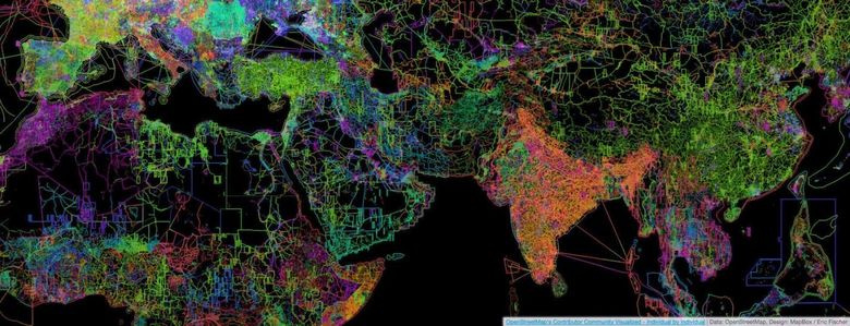
OpenStreetMap is a non-commercial mapping project in which a community of users from around the world creates an open, free geographic map. Users apply data from personal GPS-trackers, aerial photographs, video recordings, satellite images, as well as human knowledge. The closest project with which you can compare OSM is Wikipedia. Similarly, in OSM, any user edits a map, and the project data is distributed under a free license.
In OpenStreetMap, users GPS tracks and satellite images from Bing, Mapbox, DigitalGlobe are used as the basis for maps. Maps of commercial companies, for example Google and Yandex, can not be used because of legal restrictions.
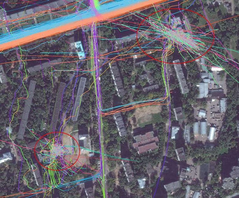
Pictures are attached to the terrain automatically at the uploading stage. Scans can also be tied with reference points with known coordinates obtained from tracks or associated with points on the geodetic network.
When editing maps, satellite images in OSM always shift in the same way as recorded tracks on the ground, compensating such most of the errors. There are a lot of applications that allow you to record GPS tracks and share them, for example, Geo Tracker, Strava (Android) and GPX Tracker (iOS).
The creator of the map first on the satellite image draws the road, using the data of the tracks. Since the tracks describe the movement in geographic coordinates, it is easy to determine from them exactly where the road passes. Then all other objects are applied. Missing and area objects are created from images, and signatures indicating the ownership of objects or supplementing them with reference information taken from observations or registers.
To create a map filled with various information, use a geographic information system (GIS), designed to work with geodata - for their analysis, transformation, analytics and printing. With GIS, you can create your own map with the visualization of any data. In the GIS for maps, you can add data from Rosstat, municipalities, ministries, departments - all the so-called geospatial data.
Where to get geodata from?
So, satellite images are shifted relative to reality in a few tens of meters. To make a really accurate map, you need to use yourself with a navigator (GPS receiver) or a regular phone. And then using the receiver or application in the phone to record the maximum number of track points. Recording is carried out along linear objects located on the ground - rivers and canals, paths, bridges, railways and tramways, etc., are suitable.
One track is never enough for any site - they too are recorded with a certain level of error. Subsequently, the satellite substrate is aligned over multiple tracks recorded at different times. Any other information is taken from open sources (or given by the data provider).
It is difficult to imagine maps without information about different companies. The collection of local data on organizations with reference to the GPS position is done by Yelp, TripAdvisor, Foursquare, 2GIS and others. The community (including directly representatives of local business) independently contributes data to OpenStreetMap and Google Maps. Not all large networks want to bother themselves with the addition of information, so they turn to companies (Brandify, NavAds, Mobilosoft and others) that help to place branches on maps and monitor the relevance of data.
Sometimes information about real-world objects is added to maps via mobile applications - right away, in the field, a person can accurately update the map data. In MAPS.ME, for this purpose, there is a built-in map editor, through which the updated data comes directly to the OpenStreetMap database. Reliability of information is checked by other members of the OSM community. In the "reverse side" the data from the OSM comes in MAPS.ME in a "raw" form. Before they appear on the screen of the user's smartphone, they are processed and packed.
Digital cartography and GPS navigation 30-08-2017