News about maps
Digital cartography and GPS navigation
Mapstor news
This Day in History
Travelling with mapstor.com
This Day in History
4th December, 1674 Marquette founded the first European settlement
19th November, 1875 was born Hiram Bingham
18th November, 1832 was born Nils Adolf Erik Nordenskiöld
14th November, 1963 the island Surtsey was founded
11th November, 1729 was born Louis Antoine comte de Bougainville
11th June, 1770 was discovered the Great Barrier Reef
 On the 11 of June 1770 during the first circumnavigation of James Cook was discovered the Great Barrier Reef.
The expedition started in August 1768. Travel map shows that the sailors sail off from Plymouth, reached the shores of Tahiti, went to New Zealand, passed along the west coast, reached the Gulf of Queen Charlotte and in April 1770 arrived to the shores of Australia, stayed at Botany Bay, and then proceeded along the eastern coast of the continent.
On 11th of June 1770 ship ran aground, plating was severely damaged. The vessel was got ashore and repaired. When the ship was launched on again, it turned out that it is separated from the sea and is located in the strip of water between the shore and the reef. To get around the Great Barrier Reef, the Mariners had to cover a distance of 360 miles.
Topographic map shows that the reef is located in the Coral Sea, not far from the northern part of Australia, and begins at the southern tropic (between the towns of Bundaberg and Gladstone) and ends at the Torres Strait thus separating New Guinea and the Australian continent. If in the northern part of the ridge width is 2 km, in the south – 152 km.
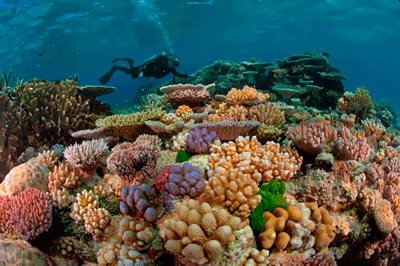
Topographic map shows that the ridge extends over 2500 km along the eastern coast of Australia and covers an area of 340 000 sq. km, which exceeds the size of many countries, such as Great Britain. It is the largest system in the world's coral reefs, which can be seen even from space. Besides, it is the largest object on our planet, created by living organisms. Reef structure is composed of billions of coral polyps forming reefs, some of which eventually turned into islands and amaze with its beauty and richness of fauna. In total, the system has about 900 of such islands and 2500 reefs.
In 1981 Great Barrier Reef was recognized as a World Heritage Site.
This Day in History 11-06-2014


