


News about maps
Digital cartography and GPS navigation
Mapstor news
This Day in History
Travelling with mapstor.com
This Day in History
4th December, 1674 Marquette founded the first European settlement
19th November, 1875 was born Hiram Bingham
18th November, 1832 was born Nils Adolf Erik Nordenskiöld
14th November, 1963 the island Surtsey was founded
11th November, 1729 was born Louis Antoine comte de Bougainville
16 May 1596 - The beginning of Barents third expedition to the East Indies
 On 16th of May, 1596 began the third expedition of Willem Barents, the goal of which was to find a northern route to the East Indies. During this voyage Bear Island was discovered and Svalbard for the second time (after the Russian Arctic mariners). Then travelers skirted the New Earth and reached the Kara Sea, where the ship was captured in ice. In order not to perish in the ice, sailors went ashore and decided to wait out the winter there. It was the first wintering in the history of Western Europeans in such a high Arctic. The main result of this travelling was the creation of Novaya Zemlya map.
The wintering was hard; there was a shortage of food. Almost all the team members were ill with scurvy, Barents was seriously ill as well, but kept up the spirit. Illness did not kept Barents from making the map of Novaya Zemlya and charting all the west coast of Novaya Zemlya. He was the first ever to hold a series of oceanographic and meteorological observations. For several centuries his daily records of weather and wind direction and the map of Novaya Zemlya were the only materials that characterize the climate of the northern part of Novaya Zemlya.
By June 1957 the Kara Sea freed from the ice, but the bay where the ship stopped was still in the ice. Sailors decided not to wait until the ship freed from ice and on June 14, 1597 the team on two boats went to the Kola Peninsula. On 20th of June Barents died. On 1st November the surviving crew members returned to Amsterdam, where no one waited their return and believed dead. Though they failed to find a northern route to Asia, they made important discoveries and Novaya Zemlya map.
After 274 years, in 1871 the Norwegian Captain Carlsen found an untouched winter hut of Barents in the Ice Harbor. There were diaries and maps of Novaya Zemlya, which contained the measurements of sea bosom and other materials.
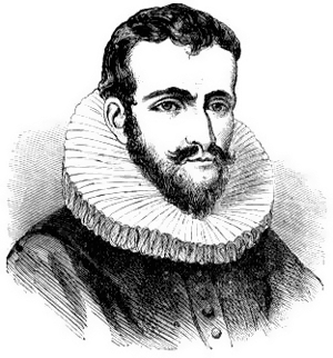
Willem Barents - navigator and Arctic explorer, a Dutchman by birth, a cartographer by trade. He is known to have participated in three expeditions to the Arctic, whose main goal was to find a northern route to India and China. Barents believed that there was an ice-free route through the Arctic Ocean.
The main reason to search the northern sea route to Asia was the total control of Portugal and Spain over a long way to India at that time. However, not one of the three expeditions had achieved its main goal. And after the beginning of the XVII century when the Netherlands discovered the straight path the Cape of Good Hope - Sunda Strait, there was no need to find the northern route.
Willem Barents learned seamanship and cartography in the Plancius studio in Amsterdam. Among other achievements one should note that together with his mentor Petrus Plancius Barents drew a map of the Mediterranean, which was the result of his voyage to Italy and Spain. After that, Barents received his navigator diploma, which is now stored at the Maritime Museum in Amsterdam.
Barents Sea, island near western coast of Novaya Zemlya, as well as a town and one of the islands of Spitsbergen are named in honor of this traveler.
This Day in History 16-05-2012