


News about maps
Digital cartography and GPS navigation
Mapstor news
This Day in History
Travelling with mapstor.com
This Day in History
4th December, 1674 Marquette founded the first European settlement
19th November, 1875 was born Hiram Bingham
18th November, 1832 was born Nils Adolf Erik Nordenskiöld
14th November, 1963 the island Surtsey was founded
11th November, 1729 was born Louis Antoine comte de Bougainville
16th November, 1824 the Murray River was discovered
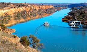 On the 16th of November 1824 researchers, colonists Hamilton Hume and William Hovell discovered the longest river in Australia - Murray. Hume later wrote that they were on the side of the great and beautiful river, called Hume. "This is a broad and, apparently, a deep river, the flow speed of which is about three miles per hour, but in spite of this the water is bright and clear." In 1829 Charles Sturt River explored the river and renamed it in honor of Murray, George Murray- head of the colonies at that time.
Hume and Hovell, accompanied by a companion went from the Blue Mountains to the west arm of Port Phillip Bay. On the map you can trace the route of the expedition that started from settlements near Lake George, Murrumbidgee River, which flows here in the north, along the foothills of the Australian Alps to the largest waterway in Australia - Murray River and its left tributaries - the Goulburn and Ovens. Next travelers climbed the Goulburn Valley and rounded the south- western spur of the Australian Alps.
In those years, the colonists developed new lands in search of pasture. Hume and Hovell explored the Murray River basin area and found that to the west of the Great Dividing Range are high mountains (the discoverers called them Australian Alps) and the vast expanse of fertile land. According to the memoirs of Howell, he never had to see the best pastures for sheep. Soon, the first settlers flocked here. Energetic businessman John Batman established a company "Port Phillip Assoshieyshn" for the development of new territories. Thus was founded the city of Melbourne, which has become the second most important center of Australia.
Even after Hume and Hovell expedition, riddle of the rivers flowing down the slopes of the Dividing Range has remained undisclosed. Howell believed that the rivers flow into the lake, which on the south-west or the north-east joins to the ocean. But this assumption proved to be wrong.
Topographic map of Australia shows that the Murray River is the largest on the continent, 2589km long and it covers about 1,000,000 sq. km. Its sources originate in the Australian Alps, where the river flows through the plain, and empties into Lake Alegzandrina adjacent to the coast of the Great Australian Bight, which is part of the Indian Ocean. Full-flowing river in the summer, in winter shallows. Widely used for water supply and irrigation. Geographic map shows that the river and its tributaries are large reservoirs, hydroelectric power plants. The valley is of great agricultural importance. The irrigated area is 400,000 hectares.
This Day in History 16-11-2013