Articles about maps
History of cartography
All about topographic maps
Topographic maps and traveling
Two centuries of Russian Cartography
Navigation software and offline maps
Navigation software and offline maps
Create seamless multi-level maps based on sets of topographic maps for SAS.Planet
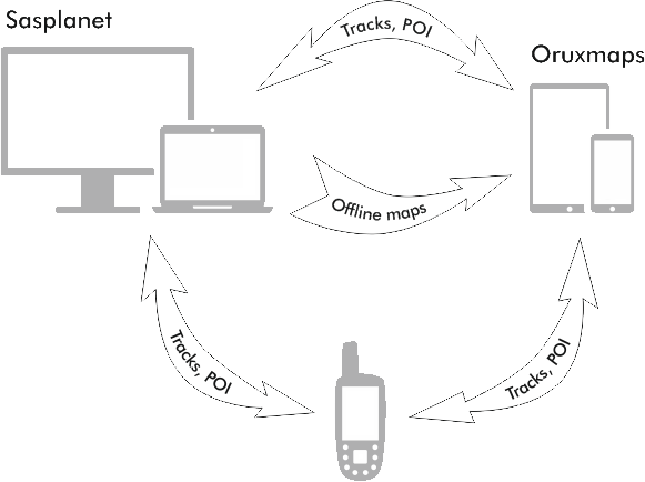
Organize interaction between PC and smartphone/tablet when preparing offline maps
Organize interaction between PC, smartphone/tablet and GPS while preparing tracks
Track plotting and storage in SAS.Planet
Organize interaction between PC, smartphone/tablet and GPS while preparing tracks

Distribution of tasks between devices
PC - Sasplanet:
- Personal database of waypoints and tracks
- Plan and plot tracks
- Create offline maps
Tablet - Oruxmaps:
- Navigate in the car
- Get directions in the field conditions
GPS:
- Record of the current track of the track (track log)
- Navigation on track
Transfer of tracks and points between SAS.Planet Oruxmaps
- In SAS.Planet tracks and points can be exported in gpx format. To do this, call the list of tags by selecting the main menu Placemarks> Placemark Manager and click with right mouse button on a single track or a group and select Export placemarks
- Next, select the format GPS Exchange files (* .gpx) and save it in a folder
- These files are transferred to your tablet or smartphone
- In Oruxmaps menu Routes> Load KML/GPX open them for navigation
Similarly we do to migrate in the opposite direction. Saved gpx file transfer to your computer and click on import in Placemark Manager window in the right corner. Imported data transfer in the convenient category for later use.
Please note that SAS.Planet cannot save data on the altitude profile of the track. For this reason save gpx files, if necessary.
Tansfer between tracks and points in Sasplanet and GPS
For loading tracks or POI in GPS, or download it from GPS we need GpsBabel utility. It supports a huge amount of different formats of GPS data, which somewhat complicates the selection of the necessary from a long list.
Switching between File or Device determine what and in which direction we want to transfer. As an intermediate format for transferring you can use .kml or .gpx. In the program SAS.Planet use import or export of relevant data.
Transfer between Oruxmaps and GPS
To connect the GPS and the tablet you need OTG USB cable, through which one connects USB sticks to the tablet.
Next by transferring GPS in mass storage mode, you can access on your tablet he content of GPS flash card. To share the data use .gpx format that is supported by most devices.


