


News about maps
Digital cartography and GPS navigation
Mapstor news
This Day in History
Travelling with mapstor.com
Digital cartography and GPS navigation
115 years of flight
Next-generation of GPS satellites are headed to space
DJI Phantom 4 RTK - cartography of a new generation
Earthquake prediction systems
OneSoil map
Google Ocean will let users explore shipwrecks and reefs in the deep blue sea
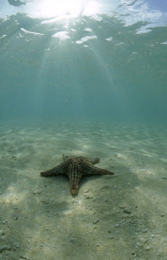
They cover two thirds of the globe and contain 80 per cent of all life.
Yet the oceans are such as mystery that we know more about the surface of the Moon than we do about the undersea world.
Now for the first time, aspiring Jacques Cousteaus will be able to explore every square mile of the sea from the comfort of their own homes.
The latest version of Google Earth lets people plunge beneath the sea, swim around underwater volcanoes, hover above shipwrecks and navigate mountains on the sea bed.
The Ocean in Google Earth software also includes video and photographs of thousands of marine species, and lets virtual divers follow whales and sharks tagged with satellite tracking devices.
The undersea 3D world was created with help from more than 25 leading marine scientists.
National Geographic Society oceanographer Dr Sylvia Earle said: "I cannot imagine a more effective way to inspire awareness and caring for the blue heart of the planet."
"For the first time, everyone from curious kids to serious researchers can see the world, the whole world, with new eyes."
"In a stroke, Google Earth brings life and character to the blue part of the planet, and makes obvious the many ways land, water, atmosphere and living systems connect."
Sylvia Earle, ocean explorer, cheers the new Google Earth 5.0 at the California Academy of Sciences in San Francisco
The virtual ocean is available for free by downloading the latest version of Google Earth from the Google homepage.
Google Earth lets people hover over a virtual world, created by piecing together tens of thousands of satellite maps.
The new version includes a three dimensional map of the sea floor, including the Mid Ocean Ridge, the world’s longest underwater mountain range stretching 30,000 miles.
Most of the sea bed is shown in relatively low resolution. But some areas - such as the Pacific Ocean around Hawaii are highly detailed.
The software also shows protected areas of the ocean and lets people follow the movement of sea animals tagged with satellite trackers.
It also displays historical images on land and sea - allowing people to watch the melting of glaciers, the construction of Germany’s football stadia in the run up to the 2006 World Cup, the shrinking of Lake Chad in Africa and the melting of the Arctic sea ice.
Broadcaster Sir David Attenborough said the site’s wildlife films contained "some of the rarest and most amazing creatures you will ever see".
He said: "It is surely an extraordinary privilege not only to be able to see the great jungles and deserts of the world in Google Earth, but also now, thanks to the Ocean project to be able to explore the bottom of the sea."
Prof Ed Hill, director of the National Oceanography Centre, Southampton added: "Understanding the oceans" role in climate change is the biggest challenge facing us in the coming years.
"We need to reach out to everyone to add to our global understanding of a world that is remote and largely undiscovered."
The Google Earth software has been downloaded more than 500million times since it was launched in June 2005.
Digital cartography and GPS navigation 11-02-2009