


News about maps
Digital cartography and GPS navigation
Mapstor news
This Day in History
Travelling with mapstor.com
Digital cartography and GPS navigation
115 years of flight
Next-generation of GPS satellites are headed to space
DJI Phantom 4 RTK - cartography of a new generation
Earthquake prediction systems
OneSoil map
The route from Västerås and Esso: mapping of fictional and real worlds
Fictional worlds often become an outlet for the cartographer. Where else can one not restrain your talent and create, enjoying the very fact of creating a detailed plan of the terrain? Even scientists are conducting experiments to create maps of fictional worlds. Researchers from the University of Lancaster in three years plan to create a program that will itself extract elements for geolocation from the art texts and on their base build animated 3D images of the relevant places. The first training will be held on the trilogy of JRR Tolkien.
Practically for every large-scale fantastic work it possible to create a map. Usually the matter is limited to the imagination of the reader. Sometimes a real artist or a cartographer draws a map - for example, a map of the Beclan Empire appeared from Richard Adams' novel "Shardik", which was painted by the famous illustrator-cartographer Rafael Palacios.
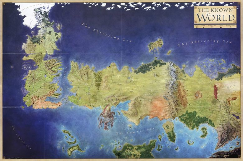
It happens that the author of the book draws the map himself. This makes it easier if the events of the novel are based on real stories. Even the fantasy with dragons and magic does not appear in an empty place - the hero needs a route, and the writer - the inspiration. Today, together with MAPS.ME, we will study the basics of the real mapping of George RR Martin's "Song of Ice and Flame".
Details of nonexistent worlds
First, let's define that there are two universes of the main modern fantasy saga. There is a series of novels "The Song of Ice and Flame", supplemented with the prequel of the wandering knight, the guidebook "The World of Ice and Fire", comic books, cookbook, calendars, artobics , Posters, maps, games, literary essays, published under the editorship of Martin.
If you are not familiar with the world of FPGAs, just believe: about the saga is written even more than the five published books of the main editions. Large-scale content is accompanied by a large number of illustrations, in which a special place is occupied by maps. It so happened that the world of Martin is extensive and filled with many small details - the action takes place on several continents, and the characters all the time move somewhere, opening one location after another.
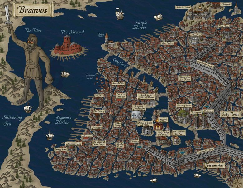
When the artists (and Martin, hanging over them) ended up with all the vast territories, it was time for the cities. Natalia Rekutz created the plans of the seven cities of FPOs, of which the writer created only two.
FPGA maps are incredibly detailed (for fictitious places). They are supplemented by a search, boundaries, scale, footnotes, links to articles, schemes for the movement of characters in books, a description of places in which heroes in principle have not been. Here you can find a giant interactive map, which literally included all the geodata ever gleaned from the vast works of Martin. And here Russian-speaking community has collected dozens of famous maps of the world, including obsolete ones.
The foundation of the real world
The second FIO universe, existing in parallel with the first one, is built on TV screens - it is a series of "The Game of Thrones", in which the action has already outstripped the plot of all the books published in places and entered the field of suspense. The series relies on the book basis and the kingdoms on the television screen are the same as in the book. The only difference is that Vasteras, Esso and other locations did not appear with the help of special effects alone. Filming took place in Ireland, Iceland, Malta and Croatia.
Fiction and truth
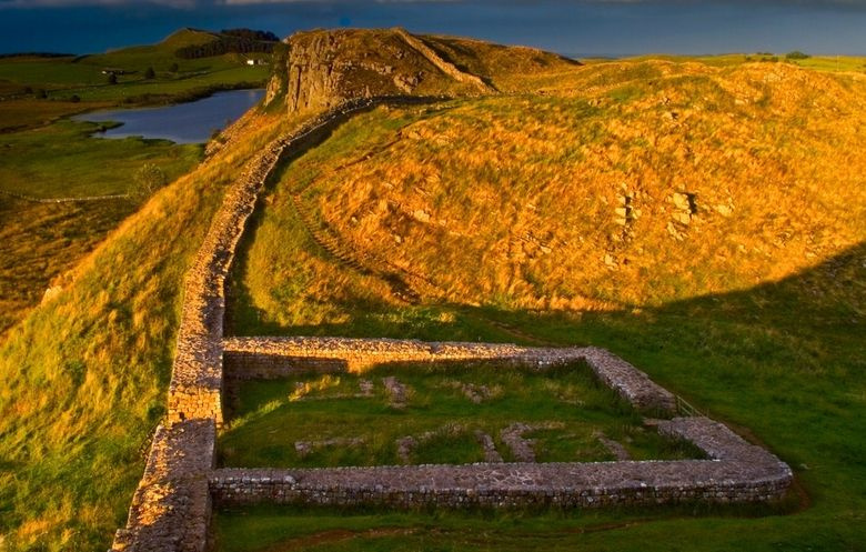
In all this story there is one place where fiction, reality and cartography come to each other as close as possible - this is the Wall that protects the Seven Kingdoms from the White Walkers. The prototype for the Wall was the Adrian Wall - a defensive fortification 117 km long and 4-6 meters high, built by the Romans under Emperor Hadrian in 122-126 to prevent the attacks of Picts and Brigants from the north. The shaft crosses northern England from the Irish to the North Seas at the border with Scotland. The dimensions of the real wall have nothing in common with the Martin Wall, which is a monolithic block of ice about two hundred meters in height and four hundred and eighty kilometers in length. Here the writer's neural network has clearly allowed itself to wind up figures for the sake of entertainment.