


Articles about maps
History of cartography
All about topographic maps
Topographic maps and traveling
Two centuries of Russian Cartography
Navigation software and offline maps
Topographic maps and traveling
Altai region
Bicycle touring routes and topographic maps
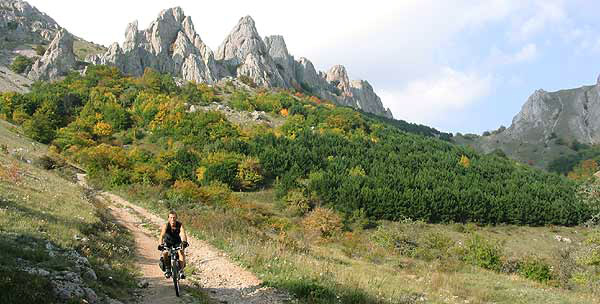
Bicycle tourism in Crimea
Bycling touring and topographic maps
Carpathian mountains
Caucasus Mountains
East Sayan Mountains
Kamchatka region
Lake Baikal
Olkhon - the heart of Baikal
Plateau Putorana
Rafting and topographic maps
Rafting directions and topographic maps. Part 1
Rafting directions and topographic maps. Part 2
Topography of China
Bicycle tourism in Crimea
Road network in Crimea
Road network in Crimea began to develop more than 2,5 thousands of years ago. And if you examine topographic map of Ukraine you will see that it considerably distinguish Crimea from other regions of the former USSR. One more important peculiarity of Crimea is the fact that it was the province of many different empires and the land where not a few state formations were formed. Each epoch built its own road network and each of them left us deserted sectors of road uninhabited, primeval, picturesque places with plenty of nature and historic sightseeing.
In the first centuries of A.D. Romans built a road through mountains (Via Military), which connect their posts in the fortress Harax (Big Yalta) and bay of Symbols(Today Balaklava). It is considered that exactly this bay was described by Gomer, when he told about Lestrigons.
At the extension of Middle Ages Mountain Crimea had more considerable population density and higher marketability of agriculture and crafts than now. In those times a branched network of horse paths was formed, the most of which lost its economic significance later and wasn’t developed for building roads.
Looking on the topographic map you will see that now these paths represent ideal condition for mountain bicycles.
Two big formations – Flat Crimea and Crimean Mountain with Southern coast line are divided into a row of regions because of difficult relief and big irregularity of coast. Each of them is interesting for MTB tourist in its own way, excluding only central part of Crimea.
Northwestern Crimea
In the northwestern Crimea comes out far away in the sea cape of Tarkhankut. Limestone ridges obtain the height of 179 meters above sea level. They are woodless and are covered with tough small grass and are cut by ravines and gullies. On the topographic map you will see that for many kilometers there are no habitations and roads in this part of Crimea.
Some vast sandy beaches in warm bays near habitations and villages are separated by tens of kilometers of steep coast with picturesque rocks in the capes and small beaches in the shape of pockets (with width from 15 up to 300 meters) in small bays.
Water near Tarkhankut cape is surprisingly clear; it is the most popular place for diving in the former USSR. You can fish here such rare kinds of fish as mullets and sturgeons.
In antique period the region was highly populated by Scythian and ancient Greeks, that’s why this place is very popular with archeologists.
Eastern Crimea
On the contrary eastern coast of Crimea hills of Kerchensky Peninsula are stretched for a hundred of kilometers. You will notice while examining topographic map that they recall Tarkhankut, because they are also woodless, each new ascent opens new fantastical skyline. They have the same height (mountain Opyk 184 meters), the same picturesque rocky capes, “pocket” beaches, shallow bays with cast sandy beaches.
Along the coasts of Kerchensky strait and in its water tens antique settlements are found. Remains of Turkish fortresses are kept as well. Muddy Vulcans also represent some interest.
The most marvelous place for bicycling is Kazantip cape, recently declared as reserve. This is an ancient coral atoll with diameter about 4 kilometers. The highest point on the topographic map is 106 meters, central hilly pan is remarkable for sloping inclines, and to the sea there are rather steep slopes with fantastical clusters of rocks and pocket beaches.
The peculiarity of Kerchensky Peninsula is presence of plenty salty lakes, which in summer usually dry up to slick stony crust. Their banks are sometimes rather high and steep.
Two these regions Tarkhankut and Kerchensky Peninsula are remarkable for hot sun and warm summer (up 40 degrees C). However, the air is always dry.
In general Crimea differs from other sea regions by having high temperature with low humidity. Usually the humidity is about 65 %, which is optimal for European people, favorable for heart.
Southwestern Crimea
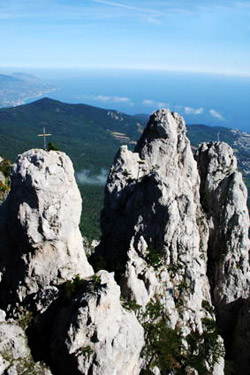
The most interesting and diverse region for mountain cycling is Southwestern Crimea (between towns Simferopol - Bakhchisaray - Sevastopol - Yalta - Alushta).Mountains with the height up to 1545 meters, difficult rocks and canyons are combined with sloping hills, cool valleys, various beaches frame seaside clutters. Humanity developed these fertile valleys tens of thousands years ago. Ancient Greeks founded towns and harbors and Byzantines in the Middle Ages founded 18 so-called spelean towns. Each of them, particularly Mangyp, represents a very interesting place for mountain bike, including the most complicated style of cycling – mountain climbing.
Modern militarization left Crimea the biggest in the world spring board for planes – trainer for marine aviation and also such unique space object as, for example, reception station saucer of space information with the square of 4 thousands square meters. Basically, you can also ride here! Reading the topographic map you will see that exactly Mountain Crimea is full of famous ancient horse paths. They affect by their flatness, but the main is that they often go through shadowy oak, beech and piny forests, filling the air with phytoncides.Each river valley abounds with ponds and storage reservoir with purest spring water.
The most magnificent mountain in Crimea is Chatyr-dag (Shater mountain). Bicycle route to its top from Angara passage is 5 kilometers with height drop about 700 meters according to the topographic map of Ukraine.
Forests of Mountain Crimea are very rich on eatable fruits. A unique monument of ecological wisdom of agriculturalists in Middle Ages are chairy – forest gardens.
Southern coast of Crimea (Big Yalta) – the most complicated region for bicycle touring because of big drops in the height, limited visibility bound at mountain serpentine and high density of habitations and resorts.
Only white south parks are good for outings and only horse paths, which are developed from imperial and king’s estates and are planted around with exotic trees. Tourists will really enjoy unforgettable sceneries from these places.
On the topographic map of southern Coast you can see mountain pastures – hilly highlands, which are practically woodless with high meadow motley grass. Unlike Tarkhankut and Kerchensky Peninsula to cycle on this road is not easy, but the network of paths, gravel roads and even asphalt roads makes it more accessible for cyclists.
The most famous and interesting mountain pasture is Ai-Petri. A cableway to the plateau is built from the town Miskhor that is very convenient for downhill fancies.
Southeastern Crimea
In southeastern coast of Crimea (Big Alushta and Sudak region) mountains do not approach tightly the coast and vast valleys near coast are made in one beachfront line. Thus from sanatorium “Utes” (west of Big Alushta) up to Sudak you can cycle along the coast, sometimes on concrete sea-fronts, sometimes on wild beaches or stony chaos.
You can go up to the famous Valley of Ghosts or to the waterfall Dzur-Dzur along the valleys of mountain rivers. Mountain pasture Karabi, which rises above this coast, is the most deserted place in Crimea – at the square of 100 square kilometers you can meet only mountain rescue post. Here you can find more than thousand of big karst holes: caves, wells, mines, which are studded with karst funnels, the most of which is usually marked on the topographic map. If there were no trees and grass, the scenery would remind you the Moon. The weather is not very hot here, because of constant winds, which also make the weather unstable, unexpected and sometimes even dangerous.
Advice about route planning
In mountain Crimea you can find bicycle touring of any degree of difficulty and for any age – from 8 to 80. But not on any bicycle. That’s why you should start route organization with looking for experienced bicycle mechanic, working exactly with mountain bicycles. It’s not a problem to buy a bicycle of famous brand, but two minutes is enough to break desperately even such a bicycle because of incorrect mechanism checkout or incorrect actions while cycling.
Naturally for the group of 6-10 cyclists there is a need to have one instructor with mobile phone and good map reading skills. The instructor should organize an accompanying car to deliver personal things, equipment for night (and also equipment for climbing, diving, paintball, etc.) to make the journey for cyclists more convenient and enjoyable.
Every tourist should have a small medicine chest, water bottle, helmet, sunglasses, for more complicated routes – knee caps, shin guards and gloves.
For bike climbing with all its unbridled power (in full spiritual and heathen sense of this word) comes Shaitan-Merdven to which goes Kalendskaya path from village Podgornoe.
A remarkable peculiarity of Crimea is a possibility to dose and complicate load to any degree in all routes. Routes in foothill or in south coast parks can be complicated by including places with places with rocks and steep slopes. Returning to already known regions will allow you to use energy, body work, pedal and gear regime more effectively, stand higher aims and receive much more pleasure.
Crimea map set is available for purchasing.